ViewNet

Context enhanced networked services by fusing mobile vision and location

vnet

ViewNet is a 1.5M GBP project jointly funded by the UK Technology Strategy Board, the EPSRC and industrial partners. The aim is to develop the next generation of distributed localisation and user-assisted mapping systems, based on the fusion of multiple sensing technologies, including visual SLAM, inertial devices, UWB and GPS.

The target application is the rapid mapping and visualisation of previously unseen environments. It is a multidisciplinary collaboration between the University and a consortium of market leading technology companies and government agencies led by 3C Research. The project is being led by Andrew Calway and Walterio Mayol-Cuevas from the Computer Vision Group and Angela Doufexi and Mark Beach from the Centre for Communications Research in Electrical and Electronic Engineering.

More information

Generic motion based object segmentation for assisted navigation

CASBliP – Computer Aided System for the Blind

casIn the CASBliP project, a robust approach to annotating independently moving objects captured by head mounted stereo cameras that are worn by an ambulatory (and visually impaired) user is proposed. Initially, sparse optical flow is extracted from a single image stream, in tandem with dense depth maps. Then, using the assumption that apparent movement generated by camera egomotion is dominant, flow corresponding to independently moving objects (IMOs) is robustly segmented using MLESAC. Next, the mode depth of the feature points defining this flow (the foreground) are obtained by aligning them with the depth maps. Finally, a bounding box is scaled proportionally to this mode depth and robustly fit to the foreground points such that the number of inliers is maximised. The system runs at around 8 fps and has been tested by visually impaired volunteers.

For more information, see CASBliP – Computer Aided System for the Blind.

Visual SLAM

vslam_matchingSimultaneous localisation and mapping (SLAM) is the problem of determining the position of an entity (localisation), such as a robot, whilst at the same time determining the structure of the surrounding environment (mapping). This has been a major topic of research for many years in Robotics, where it is a central challenge in facilitating navigation in previously unseen environments. Recently, there has been a great deal of interest in doing SLAM with a single camera, enabling the 6-D pose of a moving camera to be tracked whilst simultaneously determining structure in terms of a depth map. This has been dubbed ‘monocular SLAM’ and several systems now exists which are capable of running in real-time, giving the potential for a highly portable and cheap location sensor.

We have the following projects running on real-time visual SLAM:

  • Robust feature matching for visual SLAM: Matching image features reliably from frame to frame is a central component in visual SLAM. This project is looking at designing new techniques to achieve more robust operation by utilising image descriptors and making use of the estimated camera pose to achieve matching which has greater robustness to changes in camera viewpoint.
  • Extracting higher-order structure in visual SLAM. Previous visual SLAM algorithms are based on mapping the depth of sparse points in the scene. This project is looking at expanding the SLAM framework to allow the mapping of higher-order structure, such as planes and 3-D edges, hence producing more useful representations of the surrounding environment.

Our SLAM system is also the central component in the ViewNet project.

You can view an introduction to visual SLAM – slides from the BMVC Tutorial on visual SLAM given by Andrew Calway, Andrew Davidson and Walterio Mayol-Cuevas.

Plane Detection From Single Images

Our work involves the detection of planar structures from single images. This is inspired by human vision – since humans have an impressive ability to understand the content of both the real world and 2D images, without necessarily needing depth or parallax cues. As such, we take a machine learning route, and learn from a large set of images the relationship between image appearance and 3D structure.

There are two main parts to our method: first, plane recognition, which for a given, pre-segmented image region can classify it as being planar or not, and for planar regions estimate their 3D orientation with respect to the camera. This is done by representing the image region with standard image descriptors, within a bag of words framework enhanced with spatial information. These are used as input to a relevance vector machine classifier, to identify planes, and a regression algorithm to estimate orientation.

Second, the above is used for plane detection, where since we do not generally know the location of potentially planar regions in the image, we apply the plane recognition step repeatedly to overlapping segments of the image. These overlapping regions give allow us to calculate an estimate, at each of a set of salient points, whether they are likely to belong to a plane or not, and their likely orientation (by considering all the regions in which they lie). This point-wise local plane estimate is then segmented to give a discrete set of non-planar and oriented planar regions.

We have also shown (work in collaboration with José Martínez-Carranza) how this single-image plane detection can be useful for visual odometry, where by detecting the presence of likely planar structures from on frame while traversing an outdoor urban environment, planar features can be quickly initialised into the map, with a good prior estimate of their orientation. This allows rough 3D maps of the environment, incorporating higher-level structures, to be rapidly built.

Experimental Results

Plane Recognition

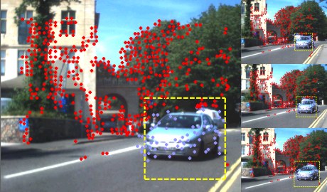
We found that the plane recognition algorithm was able to work well in a variety of outdoor scenes. As well as comprehensive cross-validation, we tested the algorithm on a set of images taken from a completely independent area of the city from the location of the test images (where the region of interest has been marked up by hand). Average classification (plane/non-plane) accuracy was 91.6%, and an orientation (normal vector estimation) error of 14.5 degrees. Some example results from this data set are shown here:

plane1-1000x205

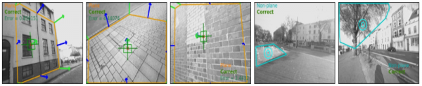
The first three show successful plane detection with estimated orientations (green) compared to ground truth (blue); the last two show identification of non-planar regions.

Plane Detection

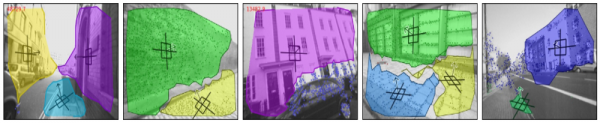
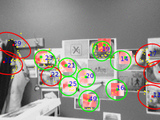
The full plane detection algorithm, involving finding planes in previously unseen images, and estimating their orientation, was also tested on an independent data set of images. A few example results are shown here:

plane2-1000x205

References

  1. Visual mapping using learned structural priors (ICRA 2013)
  2. Detecting planes and estimating their orientation from a single image (BMVC 2012)
  3. Estimating planar structure in single images by learning from examples (ICPRAM 2012)

Penguin Identification

Tilo Burghardt, Neill Campbell, Peter Barham, Richard Sherley

This early research was conducted between 2006-2009. The research aimed at exploring some first non-invasive identification solutions for problems in field biology and to better understand and help conserve endangered species. Specifically, we penguinsdeveloped approaches to monitor individuals in uniquely patterned animal populations using techniques that originated in computer vision and human biometrics. Work was centred around the African penguin (Spheniscus demersus).

During the project we provided a proof of concept for an autonomously operating prototype system capable of monitoring and recognising a group of individual African penguins in their natural environment without tagging or otherwise disturbing the animals. The prototype system was limited to very good acquisitional and environmental conditions, and operated on animals with sufficiently complex natural patterns.

Research was conducted together with the Animal Demography Unit at the University of Cape Town, South Africa. The project was funded by the Leverhulme Trust, with long-term support in the field from the Earthwatch Institute, and with pilot tests run in collaboration with Bristol Zoo Gardens.

Whilst deep learning approaches of today have replaced most of the traditional identification techniques of the 2000s, the practical and applicational insights gained in this project helped inform some of our current work on animal biometrics.

Analysis of moth camouflage

mothcam

David Gibson, Neill Campbell

A half million pound BBSRC collaboration with Biological sciences and experimental Psychology, the aim of this project is to develop a computational theory of animal camouflage, with models specific to the visual systems of birds and humans. Moths have been chosen for this study as they are a particularly good demonstrators of a wide range of cryptic and disruptive camouflage in nature. Using psychophysically plausible low-level image features, learning algorithms are used to determine the effectiveness of camouflage examples. The ability to generate and process large numbers of camouflage examples enables predictive computational models to be created and compared to the performance of human and bird subjects. Such comparisons will give insights into what aspects of moth camouflage are important for avoiding detection and recognition by birds and humans and thereby, give insight into the mechanisms being employed by bird and human visual systems