Towards Robust Real-time Visual SLAM

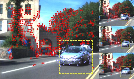
Our project investigates how to improve feature matching within a single camera Real-time Visual SLAM system. SLAM stands for Simultaneous Localisation and Mapping, when a camera position is estimated simultaneously with sparse point-wise representation of a surrounding environment. The camera is hand-held in our case, hence it is important to maintain camera track during or quickly recover after unpredicted and erratic motions. The range of scenarios we would like to deal with includes severe shake, partial or total occlusion and camera kidnapping.

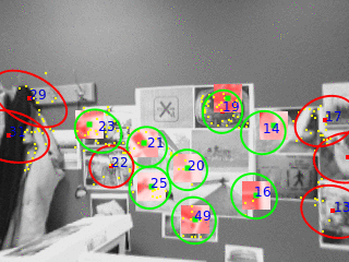
One of the directions of our research is an adaptation of distinctive but in the same time robust image feature descriptors. These descriptors are the final stage of the Scale Invariant Feature Transform (SIFT). This descriptor forms a vector which describes a distribution of local image gradients through specially positioned orientation histograms. Such representation was inspired by advances in understanding the human vision system. In our implementation a scale selection is stochastically guided by the estimates from the SLAM filter. This allows to omit a relatively expensive scale invariant detector of the SIFT scheme.

When the camera is kidnapped or unable to perform any reliable measurement a special relocalisation mode kicks in. It attempts to find a new correct camera position by performing many-to-many feature search and use robust geometry verification procedure to ensure that a pose and found set of matches are in consensus. We investigate a way of speeding up the feature search by splitting the search space based on feature appearances.

The software based on our findings is incorporated into the Real-time Visual SLAM system which is used extensively within the Visual Information Laboratory.


Place Recognition From Disparate Views

Visual place recognition methods which use image matching techniques have shown success in recent years, however their reliance on local features restricts their use to images which are visually similar and which overlap in viewpoint. We suggest that a semantic approach to the problem would provide a more meaningful relationship between views of a place and so allow recognition when views are disparate and database coverage is sparse. As initial work towards this goal we present a system which uses detected objects as the basic feature and demonstrate promising ability to recognise places from arbitrary viewpoints. We build a 2D place model of object positions and extract features which characterise a pair of models. We then use distributions learned from training examples to compute the probability that the pair depict the same place and also an estimate of the relative pose of the cameras. Results on a dataset of 40 urban locations show good recognition performance and pose estimation, even for highly disparate views.

systemdiagramsmall-822x386

Notable Results

To assess the performance of our system, we collected a dataset of 40 locations, each with between 2 and 4 images from widely different viewpoints. Since we are simply learning distributions over comparisons of places, not about the places themselves, we decided to train the system on a subset of the test dataset to maximise use of the data. To verify that the results were not biased, we tried repeatedly training the system on a random 50% subset of the dataset and running the test again. We found that the learned probability distributions were very similar each iteration, and that the recognition performance did not change by more than about 2%.

A place recognition experiment was then performed. Each image from the dataset was compared against every other image to compute the the posterior probability that the images depict the same place. The table below states the performance of our system under several conditions. The “grouped” score is simply the percentage of test images for which an image from the same place was chosen as the most likely match, simulating a place recognition scenario in which we have made a small number of previous observations of each place. It is interesting however to consider a harder case in which, for each test image, there is only a single matching image in the database. The “pairwise” score simulates this situation by removing all but one of the matching images for each test image.

We also observed that some discriminative ability of the system is provided by the different object classes – so a place with objects of class “sign” and “bollard” cannot possibly match with a place containing only “traffic light” objects. Whilst this is a legitimate place recognition scenario, we wanted to observe the discriminative ability of the features alone. Thus, we also tested the system on a “restricted class” subset of the dataset with 30 locations, all of which contained the same two object classes, meaning that almost every image was capable of valid object correspondences with every other image. Clearly this is a harder case, however the table shows that performance was still reasonable.

Grouped Pairwise
Restricted class dataset 67.9% 54.5%
Full dataset 73.1% 61.8%
GIST (Oliva and Torralba, 2001) 19.2% 21.4%

ViewNet

Context enhanced networked services by fusing mobile vision and location

vnet

ViewNet is a 1.5M GBP project jointly funded by the UK Technology Strategy Board, the EPSRC and industrial partners. The aim is to develop the next generation of distributed localisation and user-assisted mapping systems, based on the fusion of multiple sensing technologies, including visual SLAM, inertial devices, UWB and GPS.

The target application is the rapid mapping and visualisation of previously unseen environments. It is a multidisciplinary collaboration between the University and a consortium of market leading technology companies and government agencies led by 3C Research. The project is being led by Andrew Calway and Walterio Mayol-Cuevas from the Computer Vision Group and Angela Doufexi and Mark Beach from the Centre for Communications Research in Electrical and Electronic Engineering.

More information

Generic motion based object segmentation for assisted navigation

CASBliP – Computer Aided System for the Blind

casIn the CASBliP project, a robust approach to annotating independently moving objects captured by head mounted stereo cameras that are worn by an ambulatory (and visually impaired) user is proposed. Initially, sparse optical flow is extracted from a single image stream, in tandem with dense depth maps. Then, using the assumption that apparent movement generated by camera egomotion is dominant, flow corresponding to independently moving objects (IMOs) is robustly segmented using MLESAC. Next, the mode depth of the feature points defining this flow (the foreground) are obtained by aligning them with the depth maps. Finally, a bounding box is scaled proportionally to this mode depth and robustly fit to the foreground points such that the number of inliers is maximised. The system runs at around 8 fps and has been tested by visually impaired volunteers.

For more information, see CASBliP – Computer Aided System for the Blind.

Visual SLAM

vslam_matching
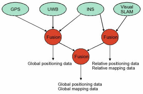
Simultaneous localisation and mapping (SLAM) is the problem of determining the position of an entity (localisation), such as a robot, whilst at the same time determining the structure of the surrounding environment (mapping). This has been a major topic of research for many years in Robotics, where it is a central challenge in facilitating navigation in previously unseen environments. Recently, there has been a great deal of interest in doing SLAM with a single camera, enabling the 6-D pose of a moving camera to be tracked whilst simultaneously determining structure in terms of a depth map. This has been dubbed ‘monocular SLAM’ and several systems now exists which are capable of running in real-time, giving the potential for a highly portable and cheap location sensor.

We have the following projects running on real-time visual SLAM:

  • Robust feature matching for visual SLAM: Matching image features reliably from frame to frame is a central component in visual SLAM. This project is looking at designing new techniques to achieve more robust operation by utilising image descriptors and making use of the estimated camera pose to achieve matching which has greater robustness to changes in camera viewpoint.
  • Extracting higher-order structure in visual SLAM. Previous visual SLAM algorithms are based on mapping the depth of sparse points in the scene. This project is looking at expanding the SLAM framework to allow the mapping of higher-order structure, such as planes and 3-D edges, hence producing more useful representations of the surrounding environment.

Our SLAM system is also the central component in the ViewNet project.

You can view an introduction to visual SLAM – slides from the BMVC Tutorial on visual SLAM given by Andrew Calway, Andrew Davidson and Walterio Mayol-Cuevas.

Context Based Compression

Richard Vigars

Supervised by: Dave Bull, Andrew Calway

State-of-the-art video coding standards (such as H.264 and H.265) are extremely reliable, and facilitate straightforward rate-quality control. However, certain scenarios remain challenging to the block-based motion and residual coding paradigm. For example, where there is camera motion with respect to highly textured surfaces, particularly if perspective effects are strong, the block-based model produces a large and highly textured residual signal.

To address this problem, we have developed a video codec framework which exploits extrinsic scene knowledge to target higher-order motion models to specific geometrical structures in the scene. We create a textural-geometric model of the scene prior to coding. During coding, we use camera tracking algorithms to track regions of salient scene geometry. Foreground regions are detected and coded by a host codec, such as H.264.

This approach allows us to replace a large volume of the host codec’s bitstream with our own compact motion parameters and side information. Compared to H.264 operating at equivalent quantisation parameters our hybrid codec can achieve bitrate savings of up to 48%.

In breif:

  • Applying extrinsic knowledge of the scene in which a video is capture in order to exploit geometrical redundancy in the motion of objects with respect to the camera.
  • A perspective motion model is targeted to planar background objects in the scene. This allows large regions of frames in the video sequence to be interpolated from reference frames. These interpolated regions are perceptually acceptable, and as such no residual is required. This translates into large bitrate savings!
  • In order to target the perspective motion model to the appropriate regions, tracking techniques similar to those used in augmented reality applications are used.

In terms of theory, this project has turned out to be quite an interesting mix of perceptual video coding and computer vision.

(Back to top)

Key algorithms

In order to extract a context from the scene a few key operations are performed:

Plane modelling.    Plane tracking     Motion estimation

From left to right these are:

  1. A set of textural models of key scene planes is extracted using SURF features. These are augmented with polygons giving the approximate locations of other planes in the scene.
  2. These models are matched to the features in each frame of the video in order to approximately localise the planar structures.
  3. These approximate locations provide an initialisation for frame-to-frame motion estimation. The use of SURF feature point matching and RANSAC isolates the background motion from that of the foreground.

(Back to top)

Foreground segmentation using anisotropic diffusion and morphological operations [1]

The process is depicted in images below:

Pixel differences between predicted frame and actual frame.     Anisotropic diffusion     Thresholding     Cleanup     Map

From left to right:

  1. Absolute pixel differences between the predicted frame, and the actual frame.
  2. These difference are then filtered using anisotropic diffusion. This smooth out invisible errors in the texture, while leaving the large errors due to differences in foreground intact.
  3. A thresholding stage creates a mask.
  4. The mask is grown into a map.
  5. Finally, cleaned up using morphological operations.

References

  1. Krutz et al – Motion-based object segmentation using sprites and anisotropic diffusion, IWIAMIS 2007

(Back to top)

Published work

  • Context-Based Video Coding – R. Vigars, A. Calway, D. R. Bull; ICIP 2013 (accepted)